Europe's wetlands mapped in unprecedented detail reveal urgent restoration needs
A new high‑resolution mapping effort shows Europe’s wetlands are highly fragmented, with restoration needs varying sharply across countries.
By Source Reporters Newsdesk
Tue, 21 July 2026 · 2 min read
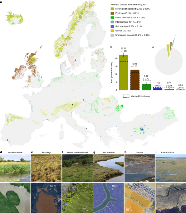
On 20 July 2026, a team led by Gábor M. Kovács published in *Nature* the most detailed maps of Europe’s wetlands to date, using machine learning on Sentinel‑1 and Sentinel‑2 satellite imagery【https://www.nature.com/articles/s41586-026-10760-9】. The analysis covered 38 European countries at 10‑metre resolution, classifying six open wetland types: inland marshes, peatbogs, salt marshes, salines, intertidal flats, and moors and heathland.
The maps show that only about 413,500 km² — roughly 6.8% of the land surveyed — remains as natural or semi‑natural open wetland【https://www.nature.com/articles/s41586-026-10760-9】. Although wetlands cover just 5–8% of Earth’s land surface, they store an estimated 20–30% of global soil carbon, making them vital for climate regulation【https://www.nature.com/articles/s41586-026-10760-9】.
The researchers found Europe’s wetlands to be highly fragmented, with 27–33% of wetland area occurring in patches smaller than 25 ha and 7–11% in patches under 1 ha【https://www.nature.com/articles/s41586-026-10760-9】. Such fragmentation complicates restoration efforts, especially under the EU Nature Restoration Regulation (Regulation (EU) 2024/1991), which requires degraded ecosystems to be restored to 30% by 2030, 60% by 2040 and 90% by 2050【https://eur-lex.europa.eu/legal-content/EN/TXT/?uri=CELEX%3A32024R1991】.
Article 4 of the regulation focuses on terrestrial, coastal and freshwater ecosystems, defining restoration as actions that move systems toward their original condition (e.g., rewetting, hydrological reconnection, pollution abatement)【https://eur-lex.europa.eu/legal-content/EN/TXT/?uri=CELEX%3A32024R1991】. The study’s authors argue that meeting these targets demands high‑resolution, standardized and regularly updated mapping of wetland extent, type and disturbance — exactly what their dataset provides【https://www.nature.com/articles/s41586-026-10760-9】.
Breaking down the area by type, moors and heathland account for the largest share at 223,662 km², followed by peatbogs at 129,325 km², inland marshes at 39,698 km², salt marshes at 11,023 km², intertidal flats at 7,191 km² and salines at 2,605 km²【https://www.nature.com/articles/s41586-026-10760-9】. The remaining wetlands are heavily concentrated in northern Europe, with Norway, the United Kingdom, Iceland, Sweden, Ireland and Finland holding the most extensive remnants【https://www.nature.com/articles/s41586-026-10760-9】.
By providing a standardized baseline, the new maps can help national authorities prioritize restoration where it is most needed and monitor progress toward the EU’s 2030, 2040 and 2050 goals【https://www.nature.com/articles/d41586-026-02211-2】.
The researchers conclude that without accurate, up‑to‑date spatial data, the ambition of the Nature Restoration Regulation risks being undermined, and they urge policymakers to adopt their mapping framework as a cornerstone of future wetland conservation strategies【https://www.nature.com/articles/s41586-026-10760-9】.
Source Reporters corrects errors promptly. Spotted something wrong? Tell us — read our editorial standards and corrections policy.