'Super El Niño' forecast to hit record strength, reshaping winter for the US and Europe
Forecasters say the 2026-27 El Niño could be the strongest in over 150 years, peaking around New Year and shifting winter storm tracks across the US and southern Europe.
By Source Reporters Newsdesk
Fri, 24 July 2026 · 2 min read
A powerful climate pattern is building in the Pacific, and forecasters warn it could rank among the strongest on record. A so-called "super El Niño" is now projected to develop through the coming months, with some forecasts suggesting it may peak higher than any El Niño in the past 155 years.
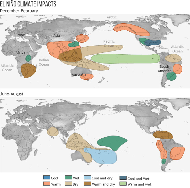
El Niño is a natural climate cycle marked by unusually warm surface waters in the central and eastern tropical Pacific. Because the ocean and atmosphere are tightly linked, that warmth ripples outward, nudging weather patterns across much of the globe.
NOAA forecasters put the odds at 63% that sea-surface temperatures in the key monitoring region will exceed 2.0°C above average — the threshold for a "very strong" event. The pattern is expected to peak between November 2026 and January 2027 before gradually weakening into spring.
For the United States, a strong El Niño typically pushes the Pacific jet stream southward, steering the storm track across the southern tier of the country. That tends to bring wetter conditions to the central and southern US, drier weather to the Northern Rockies and the Ohio and Tennessee valleys, and a milder-than-usual winter across the northern states.
The effects reach across the Atlantic too. Forecasters say the shift is likely to bring increased rainfall to southern Europe, which could ease drought in some areas while raising flood risk in others.
There is one silver lining for the current hurricane season: El Niño tends to suppress Atlantic hurricane activity by strengthening upper-level winds that tear apart developing storms, even as it favours more activity in the eastern Pacific.
Long-range forecasts always carry uncertainty, and the precise strength and timing of the event will come into sharper focus over the autumn. But the signal is strong enough that governments, farmers and energy planners are already watching closely.
A record-strength El Niño arriving on top of an already-warming planet would be a significant test — and a reminder of how a shift in one patch of the Pacific can rewrite the weather for billions of people.
Source Reporters corrects errors promptly. Spotted something wrong? Tell us — read our editorial standards and corrections policy.